


Collection:
C-MAP
Mapping
120 produits

C-MAP REVEAL Classic - NEW ZEALAND, CHATHAM I KERMADEC I
Ref : M-AU-Y622-MS
Choose your option

C-MAP DISCOVER Classic - NEW ZEALAND, CHATHAM, KERMADEC
Ref : M-AU-Y253-MS
Choose your option

C-MAP DISCOVER Classic - CAIRNS TO ESPERANCE
Ref : M-AU-Y252-MS
Choose your option

C-MAP DISCOVER Classic - CERVANTES TO SEAL ROCKS
Ref : M-AU-Y251-MS
Choose your option

C-MAP DISCOVER Classic - VICTOR HARBOR-WELLESLEY ISL
Ref : M-AU-Y250-MS
Choose your option

C-MAP DISCOVER Classic - AUSTRALIA, NEW ZEALAND
Ref : M-AU-Y060-MS
Choose your option

C-MAP REVEAL Classic - CAIRNS TO ESPERANCE
Ref : M-AU-Y012-MS
Choose your option

C-MAP REVEAL Classic - CERVANTES TO SEAL ROCKS
Ref : M-AU-Y011-MS
Choose your option

C-MAP REVEAL Classic - VICTOR HARBOR T WELLESLEY ISLANDS
Ref : M-AU-Y010-MS
Choose your option

C-MAP REVEAL Classic - PHILIPPINES, PALAU. GUAM
Ref : M-AS-Y260-MS
Choose your option

C-MAP REVEAL Classic - CHINA,TAIWAN,THAI GULF,VIETNAM
Ref : M-AS-Y226-MS
Choose your option

C-MAP 4D - Rio Oiapoque to Recife
Ref : M-SA-D904-MS
Choose your option

C-MAP 4D - ISLA DE MARGARITA TO RIO OIAPOQUE
Ref : M-SA-D902-MS
Choose your option

C-MAP 4D - South America and Continental Caribbean
Ref : M-SA-D038-MS
Choose your option

C-MAP 4D - Panama to Margarita Island
Ref : M-SA-D903-MS
Choose your option

C-MAP 4D - Japan, North Korea and South Korea
Ref : M-AN-D204-MS
Choose your option

C-MAP 4D - Continental North Asia
Ref : M-AN-D050-MS
Choose your option

C-MAP DISCOVER Classic - PEMBA TO MOGADISHU
Ref : M-AF-Y220-MS
Choose your option

C-MAP DISCOVER Classic - CAPO VERDE AND GUINEA BISSAU
Ref : M-AF-Y214-MS
Choose your option

C-MAP REVEAL classic - WEST AFRICA
Ref : M-AF-Y210-MS
Choose your option

C-MAP DISCOVER Classic - ANTARCTICA
Ref : M-AF-Y003-MS
Choose your option
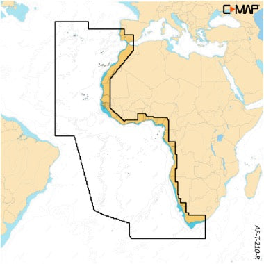
C-MAP REVEAL X - West Africa
Ref : M-AF-T-210-R-MS
Choose your option

C-MAP MAX - Pemba to Mogadishu
Ref : M-AF-M220-MS
Choose your option

C-MAP MAX - Mauritius and Reunion Island
Ref : M-AF-M219-MS
Choose your option

C-MAP 4D - Alexander Bay to Beira
Ref : M-AF-D217-MS
Choose your option
C-MAP 4D - Sao Tome and Principe Islands
Ref : M-AF-D213-MS
Choose your option
C-MAP 4D - ANGOLA COASTS
Ref : M-AF-D211-MS
Choose your option

C-MAP 4D - NORTH-WEST AFRICA
Ref : M-AF-D210-MS
Choose your option

C-MAP MAX - Mozambique Channel and Madagascar
Ref : M-AF-M218-MS
Choose your option

C-MAP MAX - Port Shepstone to Beira
Ref : M-AF-M217-MS
Choose your option

C-MAP MAX - Diggings in Durban
Ref : M-AF-M216-MS
Choose your option

C-MAP MAX - Bosluisbaai to Alexander Bay
Ref : M-AF-M215-MS
Choose your option

C-MAP MAX - Cape Verde and Guinea-Bissau
Ref : M-AF-M214-MS
Choose your option

C-MAP MAX - São Tomé and Príncipe Islands
Ref : M-AF-M213-MS
Choose your option

C-MAP MAX - Angola Coasts
Ref : M-AF-M211-MS
Choose your option

C-MAP MAX - Northwest Africa
Ref : M-AF-M210-MS
Choose your option

C-MAP MAX - Southeast Africa
Ref : M-AF-M209-MS
Choose your option

C-MAP 4D - Mauritius and Reunion
Ref : M-AF-D219-MS
Choose your option

C-MAP 4D - Mozambique Channel and Madagascar
Ref : M-AF-D218-MS
Choose your option

C-MAP 4D - Bosluis Bay to Alexander Bay
Ref : M-AF-D215-MS
Choose your option

C-MAP 4D - Cape Verde and Guinea-Bissau
Ref : M-AF-D214-MS
Choose your option

C-MAP 4D - Southeast Africa
Ref : M-AF-D209-MS
Choose your option

C-MAP 4D - Antarctica
Ref : M-AF-D003-MS
Choose your option

C-MAP REVEAL X - India, Sri Lanka, and Maldives
Ref : M-IN-T-201-R-MS
Choose your option

C-MAP DISCOVER X - Inland Eastern Russia
Ref : M-RS-T-211-D-MS
Choose your option

C-MAP DISCOVER X - Inland Western Russia
Ref : M-RS-T-210-D-MS
Choose your option

C-MAP DISCOVER X - Northeast Russian Federation
Ref : M-RS-T-204-D-MS
Choose your option

C-MAP DISCOVER X - Northwestern Russian Federation
Ref : M-RS-T-202-D-MS
Choose your option

C-MAP DISCOVER X - Kamchatka, Kuril Islands and Sea of Okhotsk
Ref : M-RS-T-013-D-MS
Choose your option

C-MAP DISCOVER X - French Polynesia
Ref : M-PC-T-211-D-MS
Choose your option

[C-MAP] DISCOVER X Chart - Red Sea, Arabian Sea & Seychelles
Ref : M-ME-T-204-D-MS
Choose your option

[C-MAP] DISCOVER X Chart - Wellesley Islands to Victor Harbor
Ref : M-AU-T-010-D-MS
Choose your option

C-MAP DISCOVER X - West Africa
Ref : M-AF-T-210-D-MS
Choose your option

C-MAP DISCOVER X - Africa and Arabian Sea
Ref : M-AF-T-050-D-MS
Choose your option

C-MAP REVEAL X - Japan, North Korea and South Korea
Ref : M-AN-T-204-R-MS
Choose your option

C-MAP DISCOVER X - Japan, North Korea, and South Korea
Ref : M-AN-T-204-D-MS
Choose your option

C-MAP REVEAL X - New Zealand
Ref : M-AU-T-622-R-MS
Choose your option

C-MAP DISCOVER X - New Zealand
Ref : M-AU-T-622-D-MS
Choose your option

C-MAP REVEAL X - Cervantes to Seal Rocks
Ref : M-AU-T-011-R-MS
Choose your option

C-MAP REVEAL X - Esperance to Cairns
Ref : M-AU-T-012-R-MS
Choose your option

C-MAP DISCOVER X - Cervantes to Seal Rocks
Ref : M-AU-T-011-D-MS
Choose your option

C-MAP REVEAL X - Wellesley Islands to Victor Harbor
Ref : M-AU-T-010-R-MS
Choose your option

C-MAP DISCOVER X - Espérance to Cairns
Ref : M-AU-T-012-D-MS
Choose your option

C-MAP DISCOVER X - Australia and New Zealand
Ref : M-AU-T-060-D-MS
Choose your option

C-MAP REVEAL X - South and East Africa
Ref : M-AF-T-209-R-MS
Choose your option

C-MAP DISCOVER X - South and East Africa
Ref : M-AF-T-209-D-MS
Choose your option

C-MAP REVEAL X - Northern and Eastern Canada
Ref : M-NA-T-209-R-MS
Choose your option

C-MAP REVEAL X - Alaska
Ref : M-NA-T-208-R-MS
Choose your option

C-MAP REVEAL X - British Columbia and Puget Sound
Ref : M-NA-T-207-R-MS
Choose your option

C-MAP REVEAL X - US West Coast and Baja California
Ref : M-NA-T-206-R-MS
Choose your option

C-MAP REVEAL X - Central America and Caribbean
Ref : M-NA-T-205-R-MS
Choose your option

C-MAP REVEAL X - Gulf of Mexico and Bahamas
Ref : M-NA-T-204-R-MS
Choose your option

C-MAP REVEAL X - Nova Scotia to Chesapeake Bay
Ref : M-NA-T-202-R-MS
Choose your option

C-MAP REVEAL X - Great Lakes to Nova Scotia
Ref : M-NA-T-201-R-MS
Choose your option

C-MAP REVEAL X - Chesapeake Bay to Bahamas
Ref : M-NA-T-203-R-MS
Choose your option

C-MAP DISCOVER X - North America
Ref : M-NA-T-200-D-MS
Choose your option

C-MAP REVEAL X - Western Europe
Ref : M-EW-T-228-R-MS
Choose your option

C-MAP DISCOVER X - Western Europe
Ref : M-EW-T-228-D-MS
Choose your option

C-MAP DISCOVER X - Central & Western Europe
Ref : M-EW-T-227-D-MS
Choose your option

C-MAP REVEAL X - United Kingdom and Ireland
Ref : M-EW-T-226-R-MS
Choose your option

C-MAP DISCOVER X - UK and Ireland
Ref : M-EW-T-226-D-MS
Choose your option

C-MAP REVEAL X - Norwegian Sea, North Sea and Skagerrak
Ref : M-EN-T-300-R-MS
Choose your option

C-MAP REVEAL X - Inland Norway and Sweden
Ref : M-EN-T-580-R-MS
Choose your option

C-MAP REVEAL X - Skagerrak, Kattegat and Baltic Sea
Ref : M-EN-T-200-R-MS
Choose your option

C-MAP REVEAL X - Iceland, Faroe Islands, Shetland and Orkney
Ref : M-EN-T-218-R-MS
Choose your option

C-MAP DISCOVER X - Iceland, Faroe Islands, Shetland, and Orkney
Ref : M-EN-T-218-D-MS
Choose your option

C-MAP DISCOVER X - Inland Waters of Norway and Sweden
Ref : M-EN-T-580-D-MS
Choose your option

C-MAP DISCOVER X - Greenland and Iceland
Ref : M-EN-T-040-D-MS
Choose your option

C-MAP DISCOVER X - Finnish Lakes
Ref : M-EN-T-326-D-MS
Choose your option

C-MAP DISCOVER X - Norwegian Sea, North Sea, and Skagerrak
Ref : M-EN-T-300-D-MS
Choose your option
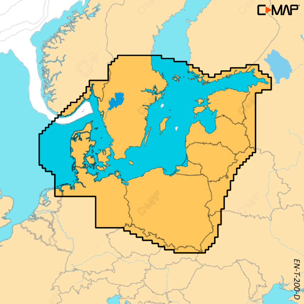
C-MAP DISCOVER X - Skagerrak, Kattegat and Baltic Sea
Ref : M-EN-T-200-D-MS
Choose your option

C-MAP DISCOVER X - Sweden, Norway, Finland, and Baltic Sea
Ref : M-EN-T-055-D-MS
Choose your option

C-MAP DISCOVER X - Northern and Central Europe
Ref : M-EN-T-050-D-MS
Choose your option

C-MAP REVEAL X - Inland Finland and Baltic Sea
Ref : M-EN-T-326-R-MS
Choose your option

C-MAP DISCOVER X - Western Mediterranean, Azores and Canaries
Ref : M-EM-T-076-D-MS
Choose your option

C-MAP DISCOVER X - Eastern Mediterranean
Ref : M-EM-T-111-D-MS
Choose your option

C-MAP DISCOVER X - Southern Europe
Ref : M-EM-T-045-D-MS
Choose your option

C-MAP DISCOVER X - Black Sea and Caspian Sea
Ref : M-EM-T-112-D-MS
Choose your option

C-MAP REVEAL X - Black Sea and Caspian Sea
Ref : M-EM-T-112-R-MS
Choose your option

C-MAP DISCOVER - Western Mediterranean
Ref : M-EM-Y200-MS
Choose your option

Gulf of Paria to Cape Horn - 4D
Ref : M-SA-D501-MS
Choose your option

Costa Rica to Chile and the Falkland Islands - 4D
Ref : M-SA-D500-MS
Choose your option

Northeast Russia MW - MAX Federation
Ref : M-RS-M002-MS
Choose your option

North-West Russia MW - MAX Federation
Ref : M-RS-M001-MS
Choose your option

Pacific Coast and Central America - MAX
Ref : M-NA-M035-MS
Choose your option

Atlantic Coast, Gulf of Mexico and Caribbean - MAX
Ref : M-NA-M033-MS
Choose your option

Gulf of Mexico - 4D
Ref : M-NA-D064-MS
Choose your option

Chesapeake Bay to Cuba - 4D
Ref : M-NA-D063-MS
Choose your option

Nova Scotia to Chesapeake Bay - 4D
Ref : M-NA-D062-MS
Choose your option

Great Lakes and St. Lawrence Seaway - 4D
Ref : M-NA-D061-MS
Choose your option


Alaska - 4D
Ref : M-NA-D028-MS
Choose your option


Western Canada, including Puget Sound - 4D
Ref : M-NA-D025-MS
Choose your option

West Coast of the United States and Hawaii - 4D
Ref : M-NA-D024-MS
Choose your option


Canada North and East - 4D
Ref : M-NA-D021-MS
Choose your option

C-MAP REVEAL Indonesia, Malaysia
Ref : M-IN-Y410-MS
Choose your option

REVEAL-X Indonesia, Malaysia
Ref : M-IN-T-400-R-MS
Choose your option

DISCOVER X - India, Sri Lanka, Maldives
Ref : M-IN-T-201-D-MS
Choose your option

European Atlantic Coasts - MAX
Ref : M-EW-M009-MS
Choose your option

North and Baltic Seas - MAX
Ref : M-EN-M019-MS
Choose your option

European inland waters - MAX
Ref : M-EN-M018-MS
Choose your option
Chargement des autres produits...
Learn more
C-MAP develops digital marine charts for preparing, tracking, and securing navigation on a chartplotter. At Skysat, this collection brings together C-MAP Discover, REVEAL, REVEAL X, Max, and 4D cartography, available based on navigation areas, formats, and your equipment's compatibility.
C-MAP charts are designed for Navico Group compatible chartplotters, including Simrad, B&G, and Lowrance devices. Before ordering, always check the exact chartplotter model, its card reader, the required format, and the software versions recommended by the manufacturer.
The Discover range is suitable for general navigation with essential information on coastlines, harbors, soundings, and navigation aids. REVEAL and REVEAL X add terrain reliefs, enhanced presentation, and functions useful for reading the bottom, depending on the area. Max and 4D editions also cover specific areas and different hardware generations.
Chart selection primarily depends on the area covered: Atlantic, English Channel, Mediterranean, Northern Europe, Caribbean, Americas, Asia-Pacific, or inland navigation. Also browse our Marine Cartography collection to compare other available formats and solutions compatible with your setup.
Marine cartography is a navigation aid: it does not replace regulatory nautical documents, watchkeeping, or regular data updates. For a complete installation, you can pair your chart with a GPS chartplotter and network accessories suitable for your onboard system.


